Introduction

Image courtesy of Gustavo Paolo via Wikimedia commons
Curitiba is a fantastic case study if you are interested in urban landscapes. Curitiba is the capital city in Brazil’s state of Paraná and is famous among urban planners for its innovation and rational development. In 1960, the Curitiba Master Plan was created, which took a different approach to urban planning by integrating layout functionality, economics, culture, and ecosystem services. In 1971 the plan was adopted, which transformed Curitiba into a model example for urban sustainability. This was formally recognized in 2010 when it was given the Global Sustainable City award.
Popular tourist attractions of Curitiba are the many parks and green spaces, which integrate environment into the urban landscape. Curitiba is classified into the Ombrophilous Mixed Forest subtype, and around the city you may find forest, steppe and other formations. Preserving these structures within parks and green spaces gives Curitiba a sense of natural variability and safeguards a wide array of ecosystem services. Some notable ecosystem services provided by these green spaces are water and sanitation, flood control, and a source for urban agriculture.
Another point of interest for Curitiba is its low carbon footprint. Curitiba emits less carbon per capita than most Brazilian cities despite the large amount of car owners. These low emissions are primarily thanks to Curitiba’s famous public transportation system, which has carried the majority of commuter traffic throughout the last decade.
If you are interested in green roofs, green building, urban sustainability, ecological services or urban agriculture this case study will be a good candidate.
Background
Energy/Resources: Solar Biofuels run public transportation Smart Grid Waste Collection Hydropower and Forest
Agriculture: Urban Agriculture Community Gardens
Conservation/Ecology: Parks in Curitiba Green Space Gets Even Bigger Cutting Deforestation in Brazil
Society/Urban: World’s Most Sustainable Cities Green city Citities for People Curitiba City Profile Urban development Slides Public Transport & Environmental Curitiba Recycling An Environmental Showcase Biodiversity Resources Urban Forest A Song of The City Sustainable Urban Living Suicides spread through tribe
Basic Geodata
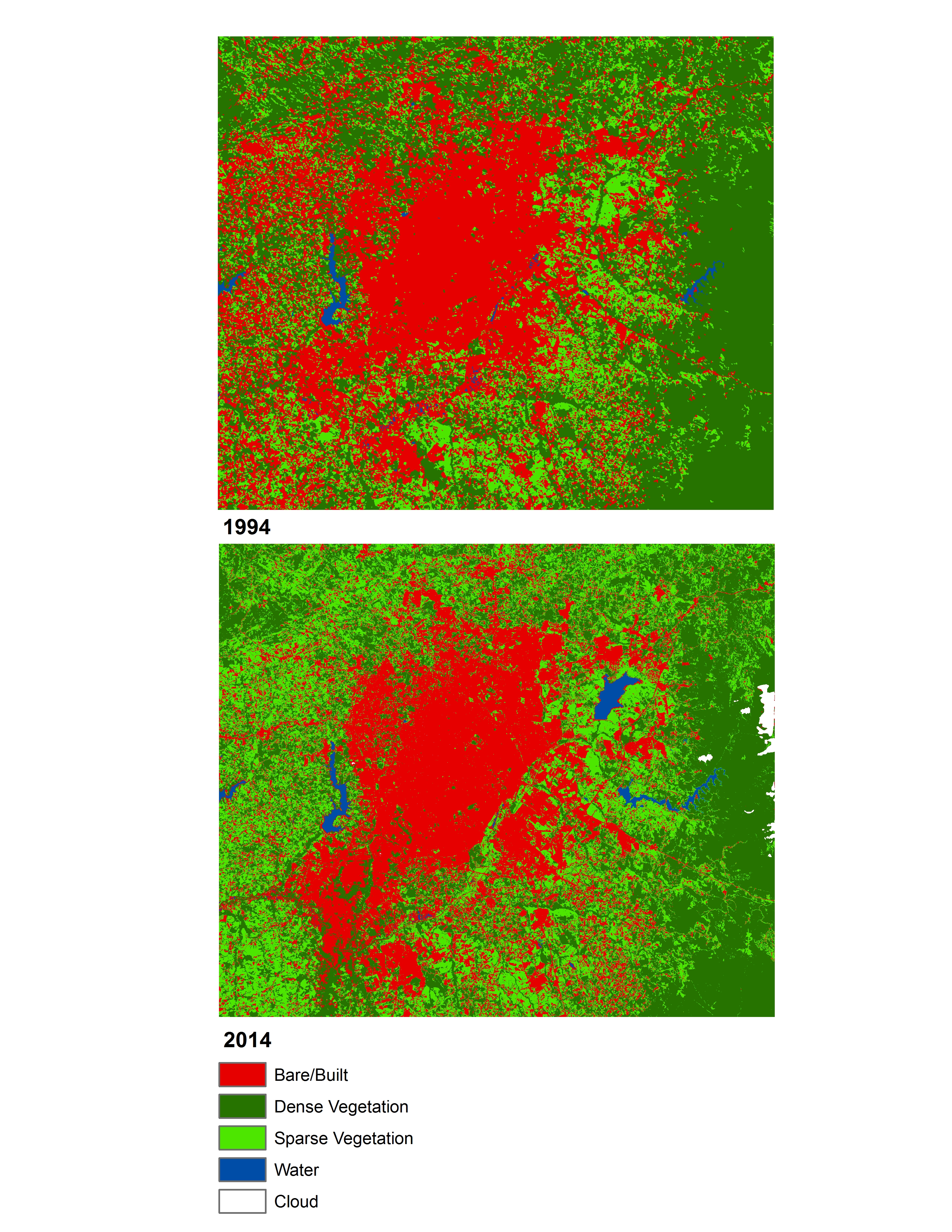
Land cover data (compatible with ArcGIS) will be provided to you in class, covering three past time periods since the 1980s. The links below will show you the approximate boundaries (as seen in Google Earth with recent years), as well as the basic changes in land cover.
view in Google Earth