Introduction
Image courtesy of Yourexhalekiss via Wikimedia Commons
Topical concerns in Belize include coastal development, mangrove loss, tourism, and rural agriculture. Belize has a low population density, atypical of Latin America, but its coastline is being rapidly developed, mainly by hotels and shrimp farms. Coastal ecosystems include mangrove forests and one of the largest coral reefs in the world, the Mesoamerican Barrier Reef. Inland are large marshy plains, caves, rainforests, and mountainous plateaus, boasting highly diverse flora and fauna. The rugged geography of the interior is in part responsible for the low population of Belize at just over 300,000 people.
The case study nearly covers the entire country, and passes into part of neighbouring Guatemala. Compared to other case studies, data availability is less of a problem here, and there is even additional spatial data that can be obtained from Dr. Steve Mitchell. While the issues facing the Belizean coast are applicable to many coastal countries, Belize is still unique in many ways due to its history and geography. For groups interested in the country for reasons beyond coastal development, Belize is almost entirely dependent upon energy imports, despite some potential for various renewables. Furthermore, the relatively high number of protected parks and areas in the country allow for interesting studies of deforestation.
Background
Energy/Resources: Energy Profile Proposal for National Energy Strategy
Agriculture: Agricultural Profile Cacao Aquaculture
Conservation/Ecology: Land Degradation Roads, Land Use and Deforestation Carbon
Society/Urban: Ethnic Diversity Mennonites Free-Spirited Chocolatier
For an academic source of information, talk to Steve Mitchell, UBC Forestry
Basic Geodata
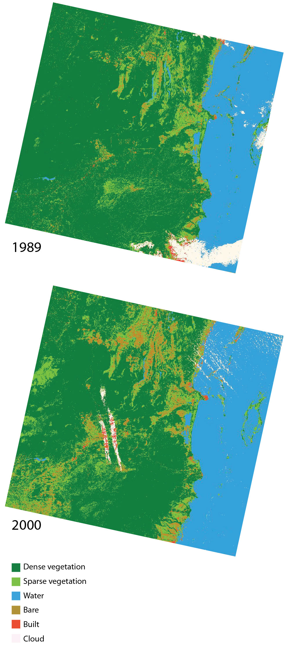
Land cover data (compatible with ArcGIS) will be provided to you in class, covering three past time periods since the 1980s. The links below will show you the approximate boundaries (as seen in Google Earth with recent years), as well as the basic changes in land cover.
view in Google Earth
Remember, in addition to Landsat-derived land cover, there are several more auxiliary geodata sets that have already been collected for you and will be provided in lab. These data include: terrain/elevation, nightlights which represent population, floristic zones, etc. and are available at all study locations. These datasets are introduced and explained further under Additional Data Sources. In addition to these ready-to-go, prepared auxiliary datasets, this page also provides ideas for additional datasets you might find on your own.