Introduction
Images courtesy of Trevor Jones, Blue Ventures
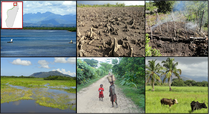
This case study looks at Ambaro and Ambanja bays in NW Madagascar, which is a complex intersection of terrestrial and marine ecosystems. Sprawling down from the western slopes of the foothills of this island nation’s tallest mountains is a tangled agro-forest mosaic intermixed with vast stretches of rice fields, savanna and woodlands. These agriculturally and aquaculturally dominated land-cover types transition into extensive mangrove ecosystems. Terrestrial forests here were integrated into the agro-forest mosaic long ago, but mangrove ecosystems are more rapidly being harvested and converted over a greater extent in this area, than anywhere else in Madagascar. Mapping efforts and extensive ground observations confirm these extensive clear-cuts (see Landsat time-lapse).
Given their dependence on the goods and services provided by mangrove ecosystems, the livelihoods of already impoverished coastal communities are becoming increasingly vulnerable. Ambaro and Ambanja bays are a particularly stimulating case study for those interested in mangrove dynamics, associated greenhouse gas emissions and underlying socio-economic issues, but also in relation to sustainable charcoal production, re-/afforestation and coastal ecotourism. This case study is also appropriate for examining monetarily valuating ecosystems, tapping into carbon financing mechanisms (e.g., REDD+), and other payments for ecosystem services. With diverse agricultural production in the area, including vanilla, cacao, coffee, and sugar-cane, Ambaro and Ambanja bays additionally provide an opportunity to consider subsistence livelihoods, but also sustainable standards, as multiple firms are seeking internationally-recognized certifications.
Beyond the provided data sets, insight from Dr. Trevor Jones can be very useful as he has an intimate knowledge of the case study area and can offer additional data resulting from his research, including estimated mangrove carbon stock values.
Background
Energy/Resources: Overview of Madagascar’s mangroves Wood Energy
Agriculture: Smallholder Vanilla Program Food Security Assessment (FAO) Rice – Coalition for African Rice Development Pest Problem
Conservation/Ecology: Mangrove forests: threats Map of Terrestrial Ecosystems of Africa Building forest carbon projects Mangrove forest distributions (1975-2005) Mangroves: carbon-rich forests Biodiversity of coral reefs of Northwest Madagascar Blue carbon: CO2 sequestration in coastal ecosystems “Blue forests” and payment for ecosystem services 50 years of deforestation and forest fragmentation in Madagascar New species of nocturnal gecko
Society/Urban: Mangroves and Fishermen Forest-reliant people and REDD+ in mangroves Use of mangrove forests and implications for management Problematizing REDD+
Basic Geodata
Land cover data (compatible with ArcGIS) will be provided to you in class, covering three past time periods since the 1980s. The links below will show you the approximate boundaries (as seen in Google Earth with recent years), as well as the basic changes in land cover.
view in Google Earth
Remember, in addition to Landsat-derived land cover, there are several more auxiliary geodata sets that have already been collected for you and will be provided in lab. These data include: terrain/elevation, nightlights which represent population, floristic zones, etc. and are available at all study locations. These datasets are introduced and explained further under Additional Data Sources. In addition to these ready-to-go, prepared auxiliary datasets, this page also provides ideas for additional datasets you might find on your own.