Introduction
A diversity of issues at this site make it an interesting case study of a social-ecological system. Ecological impacts of dam construction vary from direct impacts on streamflow as well as reservoir filling. The impacts of the construction materials used to build one of the world’s largest hydro-electric facilities are interestgin to consider, as well as the relative impacts of China obtaining power from some alternative energy source (such as coal, solar, etc.). Movement of residents is impacting the landscape mosaic in valley bottoms and mountainous slopes as corresponding changes in the location of village settlements and agricultural patterns emerge.
Knowledge of Mandarin is an asset for this case study, enabling access to numerous publications not in English, thus increasing the potential creativity of a group’s approach (e.g., comparing estimates from internal and external reports). However, any lack of familiarity should not be seen as at all restrictive to anyone interested in the area.
Background
Energy/Resources : Three Gorges Complete Changes in energy, exports, etc. Small Dams Harm Environment Nuclear Power Plans Unfazed Three Gorges Dam overview China to cap coal use International Commission on Large Dams Hydroelectric Power Water Diversion Project Solar Energy Investing in Solar Energy in Asia Pace of Chinese Development The Price of Damming Tibet’s Rivers
Agriculture: Farmland Is Polluted Too Polluted to Farm Urban Agriculture
Conservation/Ecology: Peak Phosphorus Curb Air Pollution Sets Poisonous Waterways River’s Power Threaten a Region China’s Cap-and-Trade Program
Society/Urban: Urbanization Illegal Ivory Historic Gardens
Basic Geodata
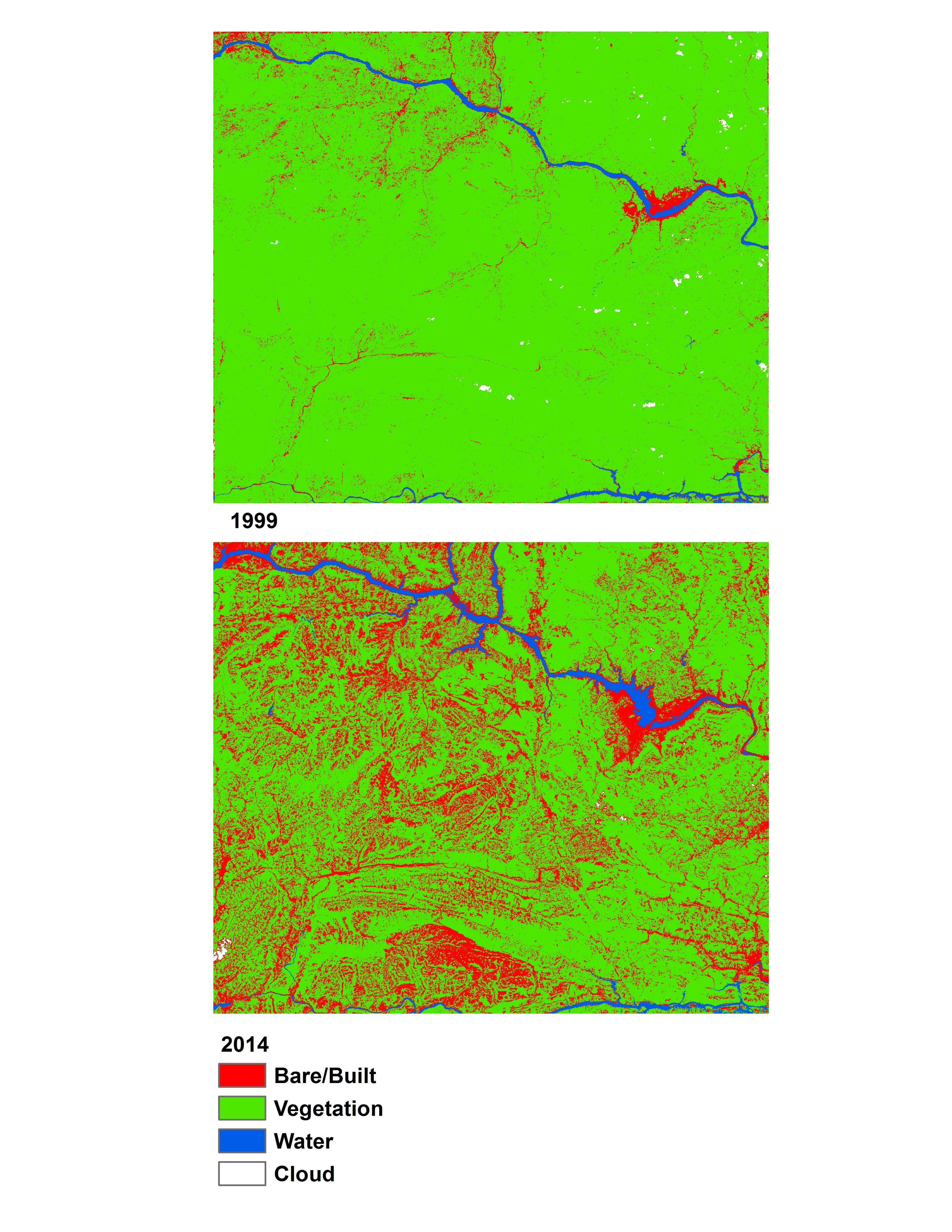
Land cover data (compatible with ArcGIS) will be provided to you in class, covering three past time periods since the 1980s. The links below will show you the approximate boundaries (as seen in Google Earth with recent years), as well as the basic changes in land cover.
view in Google Earth
Remember, in addition to Landsat-derived land cover, there are several more auxiliary geodata sets that have already been collected for you and will be provided in lab. These data include: terrain/elevation, nightlights which represent population, floristic zones, etc. and are available at all study locations. These datasets are introduced and explained further under Additional Data Sources. In addition to these ready-to-go, prepared auxiliary datasets, this page also provides ideas for additional datasets you might find on your own.